The Scajaquada Creek was once a flourishing and expansive area. In fact, it was even detailed as a “lake” from a historic map dating back to 1914. However, much development has overtaken and changed the creek and the scenic experiences it once offered, specifically the Scajaquada Expressway. Where there was once a beautiful landscape one can now spot the landfill remains of careless industries that have come and gone, Geico billboards, and a host of continuously emerging bleak features. Before long, much of the creek and the surrounding lands as we know it will be lost, but this time it will be permanent. However, by removing the expressway we could perhaps finally begin to fully restore this landscape to its once former glory.
In this series, several times I’ve mentioned replacing the Scajaquada Expressway with a “Scajaquada Drive.” But did you know there was once an actual Scajaquada Drive, that was obliterated to create part of the expressway? There’s something ouroborosian about the idea of a drive replacing an expressway that replaced a drive. But as Buffalo knows from the Commercial Slip, sometimes things come full circle, and sometimes the past points the way to solving the problems of the present for a better future.
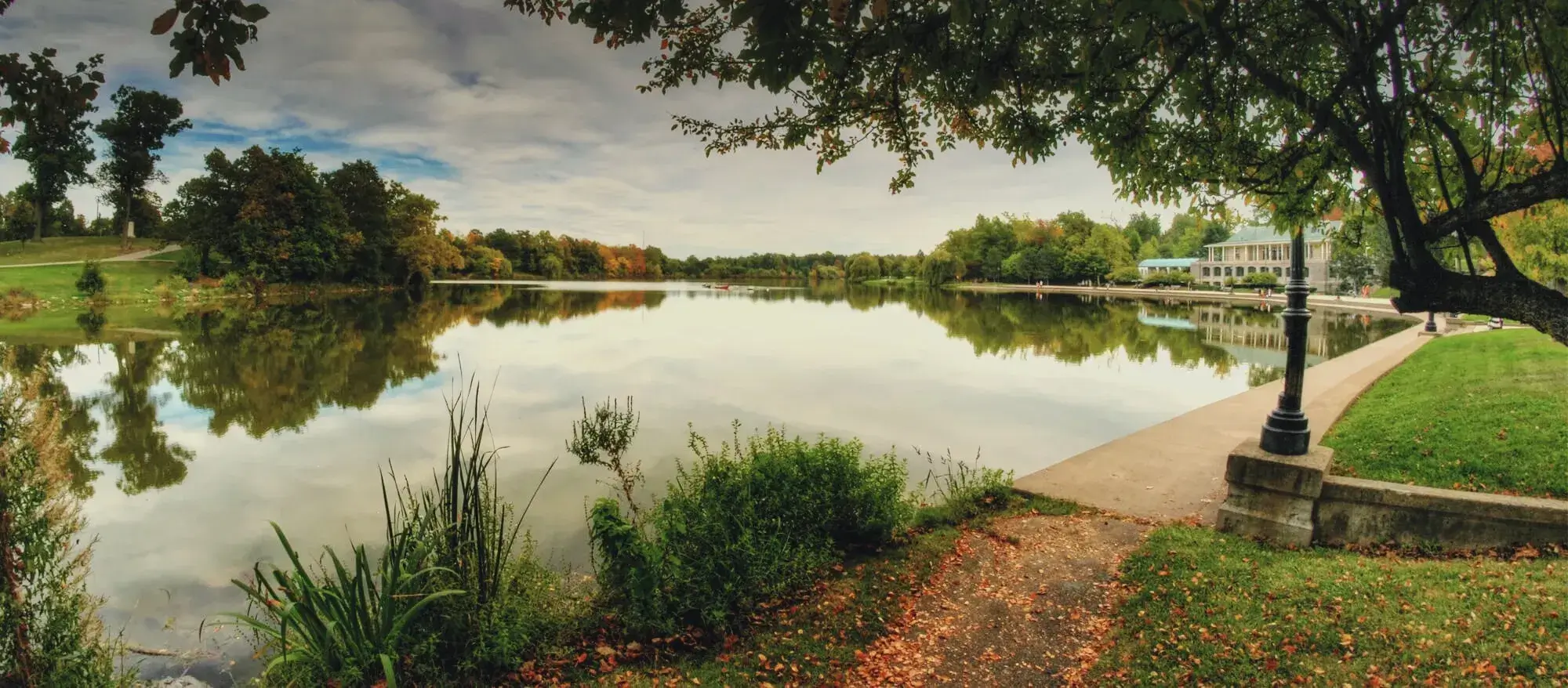
Essentially that is what remaking the western end of the Scajaquada Expressway corridor is about, west of Lincoln Parkway. As you can see from the lead image, west to Grant Street the creek was wide and there was a scenic drive alongside. The creek was so wide there that the historic photo above that we’ve published before gives it almost the appearance of a lake – and in fact the 1914 historic map detail in the lead image even has the word “lake.” The same map also shows that from Grant to West Avenue, near the end of the present expressway, was an extensive widewaters along the creek. That didn’t just have the appearance of a lake, it essentially was a small lake – a natural lake similar in size to the artificial lake that Olmsted created for Delaware Park. In fact, it was large enough to be the site of a shipyard – the very shipyard that refit Commodore Perry’s fleet that won the Battle of Lake Erie and turned the tide of the War of 1812. His motto was, famously, “Don’t give up the ship!”
But there were no Commodore Perrys in the 20th Century to implore us not to give up the historic shipyard and not to let that beautiful landscape go down without a fight. Instead, it was abandoned to its fate, pounded from all sides at point-blank range by landfill after landfill from expanding industries that set up along the railroads and circled in for the kill. Already rapidly sinking from sight, it was delivered the coup de grace by the expressway. Today, there is no trace of that landscape. But like a shipwreck it is still there, waiting to be rediscovered and even recovered.
I took a walk there recently, and sadly the only animal I saw was the Geico gecko, looking down at me from a billboard. The bleakness of the same area was captured even better by artist Alberto Rey, whose work has been shown at the Burchfield-Penney, an image we’ve published before. Could we dig up and refloat this shipwreck of a landscape? The industries are gone and the land – for the moment – is available. But not forever. With long-overlooked land in the city being snatched up at a rate we haven’t seen in a generation (a perfect example this week here), and new development happening very close by, it won’t be long before those former creek lands are lost again, perhaps permanently this time.
But the expressway in the creek holds everything back. We can’t fully restore this landscape without entirely removing it. But to do that, we first need to show – not just say – that we can do without it. It’s easy to point to other cities that have removed expressways and say, “they get along just fine without them,” and, “the traffic will just vanish.” But that strikes me as what my college physics professor Dr. Ogden would have called a hand-waving argument – and then marked me wrong for not showing my work. So while I believe I know the right solution for the west end of the Scajaquada Corridor, as painful as it is for both writer and reader, I’m going to do a derivation that I hope would be worthy of a passing grade from Dr. Ogden.
Grid and Bear It
So far, this series has gone east to west. But for this piece, rather than start where I left off in the previous installment, we need to jump all the way to the western end. It’s a little like checking the answer in the back of the book before starting the homework. As I’ve said, I believe the solution is to remove the section of the expressway in the creek valley and instead create a Scajaquada Drive made up mostly of existing and reconfigured streets. But before writing up that plan, I need to know if a limited-access expressway with over 40,000 cars per day (Average Daily Traffic) could actually be replaced by a two-lane road with a capacity of perhaps half that. So rather than jumping to conclusions, I’m jumping ahead to the end, because I believe the answer is found where the 198 meets the 190.
As I discussed earlier in the series, right now the 198 is a creature of the 190 and the 33. As on the east end, where it serves as a hand of the 33 extending fingers into the Upper West Side and portions of North Buffalo, on the west end the 198 is a hand of the 190 extending fingers into those same places. But a key difference is that on the east end, traffic from the 33 using the 198 to reach those destinations has relatively few east-west options other than to continue on the 198 to a major intersecting road. On the west end, there is much more street grid available to absorb the traffic – if only the traffic from the 190 could be better connected to it.
Another significant difference between the two ends is the way the 33 approaches the 198 vs. the way the 190 approaches the 198. Again referring to my earlier post, the 33 makes its closest approach to the West Side and North Buffalo in one place only: at the 198 split. The 190, on the other hand, has access to those areas in several places: Kenmore Avenue, Riverside Park, Ontario Street, Hertel Avenue, Austin Street, Amherst Street, the 198, Porter Avenue, and Virginia Street.
Connecting traffic volumes are also very different: the 33, at the 198 split, carries 96K cars per day. The 190 at the 198 carries 75K. On the 198 itself, the easternmost segment carries over 70K cars, while the westernmost segment carries less than 40K.
So compared to the east end, the west end of the 198 corridor is not only much grittier – essentially a post-industrial brownfield – but also much griddier. Near the 190/198 junction, in addition to the expressway, there are several east-west routes: Forest Avenue, Amherst Street, and Rockwell Road. The problem is, as I’ve noted before, expressways confine and channel traffic, and deliver it to one point. A major factor keeping traffic volumes high – artificially high, I believe – on the west end of the 198 is that traffic from the 190 is confined and channeled onto the 198 without opportunities to easily connect to those other routes.
This channeling also has severe impacts on the north-south streets bracketing Buffalo State College, the heaviest traffic destination on the western end of the corridor. There is essentially only one point where Buffalo State traffic plugs into the 190: the 198. Yet the 198 doesn’t bring that traffic directly to campus, but skirts it. So all the Buffalo State traffic gets channeled onto either Grant or Elmwood to access campus. That adds congestion and the need for otherwise unnecessary lanes to those critical urban streets. That not only creates traffic snarls, and degrades the urbanism and walkability near campus, but it can have cascading effects miles away by tying up vital bus lines at exactly the times of day when those routes need to function most efficiently.
It seems clear that the fix for these issues is to use the east-west routes as a grid to absorb and disperse the traffic coming from the 190. I believe that grid would be robust enough to enable the western end of the four-lane Scajaquada Expressway to be replaced with a two-lane Scajaquada Drive. But to satisfy Dr. Ogden, I still need to be more specific in showing how that would work. And I wouldn’t dare submit my homework without a diagram.
How That Would Work
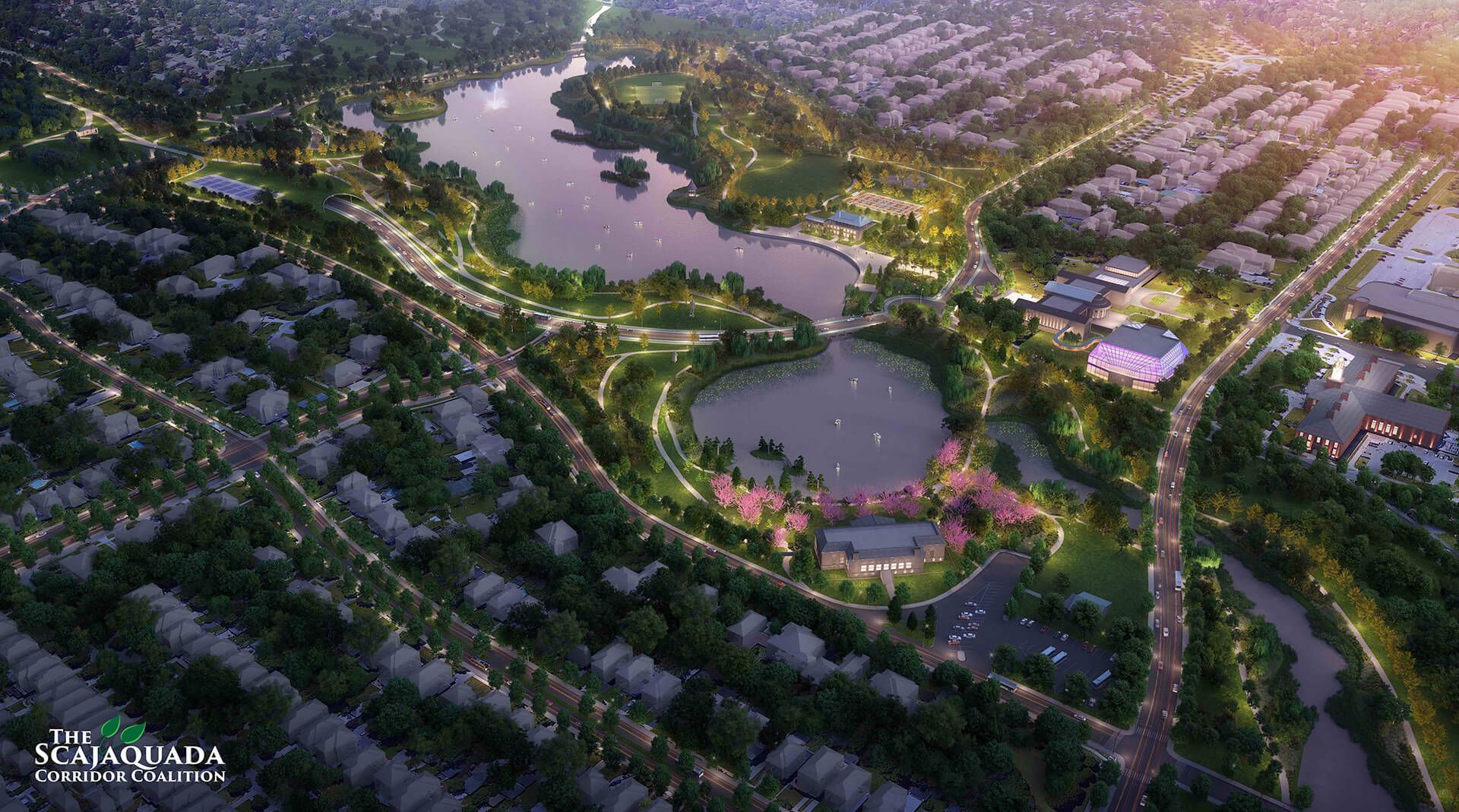
Standing at the end of the Scajaquada, looking up at the 190/198 junction, you can see why it has earned widespread loathing. It’s easy to imagine its crazy mass of airborne tentacles being the inspiration for the Church of the Flying Spaghetti Monster, or vice-versa. Someday, it would be great to see it all dismantled. The Western Scajaquada Coalition has some great graphics showing a better world without it. But there are no plans for that in the offing. And insisting on the junction’s entire removal in a re-do of the 198 could be a deal-breaker, or at least hold things up so long that the land to restore the widewaters is no longer available. Still, I believe we could take a big step in that direction – ironically, by adapting part of the monster itself.
The key is the unique way this Spaghetti Junction of ramps flies over Niagara Street then dips down, nearly to ground level. The ramps have to do that in order to merge with the two ground-level ramps from the Niagara Street/Tonawanda Street intersection. The merged ramps then rise together to cross West Avenue and form the elevated section of the 198. At its lowest point, west of West, this collection of ramps is just seven or eight feet off the ground. You can reach up and scratch the monster’s belly – if you dare.
Using that key, my proposal here has four basic elements (see diagram, below):
- Entirely remove the ground-level ramps that plug into the Niagara/Tonawanda intersection;
- Create the western end of Scajaquada Drive running from the Niagara/Tonawanda intersection, across West Avenue, and along Fernwood Avenue (using a portion of the footprint of the southern ground-level ramp);
- North of where Scajaquada Drive would cross West Avenue, use available land to create a “Scajaquada Circle” (or roundabout); and
- Bring the 190 on/off ramps the rest of the way to ground level, and link them into Scajaquada Circle, where they would end.
Note that most roundabouts are 100 to 200 feet in diameter, and there is enough land at that location for a circle or roundabout with a diameter of 200 feet or more.
This solution would essentially create a traffic machine to diffuse the point-source flow from the 190 into the street grid as evenly distributed as possible. Because after all, although Olmsted and Vaux popularized circles for park planning, circles are, essentially, simple and elegant traffic machines, with no moving parts other than their users.
Under this arrangement, traffic from the 190 hitting Scajaquada Circle would have several readily available options, rather than just one presently. Among them are:
- Taking West Avenue to Forest Avenue, where it can head east to Grant Street, Elmwood Avenue, or Delaware Avenue, or head west to Niagara Street;
- Taking West Avenue to Tonawanda Street, where it can head north to Amherst Street or south to Niagara Street;
- Taking Scajaquada Drive from West Avenue to the intersection of Niagara and Tonawanda Streets (west end) or east to Grant Street, Buffalo State campus, Elmwood Avenue, Lincoln Parkway, and points east;
- Taking Scajaquada Drive from West Avenue to Rockwell Road, where it can head into Buffalo State campus or to Elmwood Avenue;
- Taking Scajaquada Drive from West Avenue to Nottingham Terrace, where it can head to Elmwood Avenue, Lincoln Parkway, Delaware Avenue, or Amherst Street.
This plethora of possible pathways provides the potential to disperse traffic enough to allow Scajaquada Drive to function as a two-lane road, perhaps with a center turning lane where necessary. Local drivers especially, who know their way around town, would be able to use this mechanism to seek out the quickest and least crowded routes to their destinations. Visitors and those using GPS would likely still be directed to take Scajaquada Drive, as they are directed to take the expressway today.
Note that in this proposal, the ramps from the 190 don’t directly connect with Scajaquada Drive at the circle. Rather, they are connected with West Avenue. Traffic can easily reach Scajaquada Drive, but only by turning from West Avenue. This way, drivers are not only provided with alternative routes upon leaving the 190, but actually encouraged to try them.
While this proposal would mainly affect the western end of the corridor, its traffic-dispersing effects could be felt farther east. That is why I suggested in a previous article in the series that it may be possible to reduce the traffic on the section of the road through the park enough to allow it to be reduced to two lanes from four – at least, between Elmwood and Delaware Avenues.
Starting at the End of the Road
With all that derivation out of the way – whew – let’s consider what a Scajaquada Drive replacement for the western end of the expressway could actually look like.
Scajaquada Drive would begin at the intersection of Niagara and Tonawanda Streets, making the intersection four-way. That would dramatically improve a challenging intersection for all users – drivers, cyclists, and pedestrians. The beginning of the road would also serve as a gateway to the Scajaquada Creek corridor, which could be beautifully restored with the removal of the expressway. The drive then would also function as a gateway into an Olmstedian landscape, perhaps akin to the drives linking Boston’s fens along the Emerald Necklace. As a gateway into a restored landscape, the western end should be designed perhaps akin to the entrance to a park, including appropriate design elements such as a monument sign.
At Spaghetti Junction, the northern (off) ramp would be entirely removed, and Scajaquada Drive would begin on the footprint of the southern (on) ramp. The initial straight segment would allow a direct line of sight between the very end of Scajaquada Drive and the Black Rock section of Niagara Street. That would provide a short visual and mental transition zone for those entering and leaving the drive, between the urban street grid and what should be a softer, more natural landscape along the drive and the creek.
After passing under Spaghetti Junction, and crossing West Avenue, Scajaquada Drive would continue along the alignment of Fernwood Avenue. Where it would go from there would depend on land use decisions. More about that in the next installment.
Of course there would be provisions for cyclists and pedestrians, and an upgraded Scajaquada Pathway/Jesse Kregal Trail should be designed in, as well.
A New Beginning at the End of the Creek
Plans for Scajaquada Drive and for Scajaquada Creek should be considered inseparable and should inform and influence each other. For example, the layout of the drive east of Fernwood Avenue would depend on how much of the widewaters can be restored. The end of the drive also corresponds to a transition zone on the creek: on historic maps, the widewaters transitioned into a channelized creek mouth where West Avenue is today. With the expressway removed and widewaters restored, the bend in West Avenue would provide a view along the entire length of the widewaters, likely making it a destination for photographers.
The role of West Avenue is crucial, as well. At Forest Avenue, West Avenue would provide the link between the dense street grid of the West Side and this more natural landscape. The Monarch 716 student housing development recently built at that location has buildings on either side of West Avenue at Forest, set far back from the street. So there is room for extensive landscaping along both sides of the street to transform it into a natural gateway. There might even be enough width there to create a planted median, a short, mini Olmstedian parkway. Above all, it is important to use good street design to calm traffic there, as drivers coming from and to an expressway often use connecting streets as speedways. Also, a traffic light.
At Tonawanda Street, West Avenue has an outstanding industrial vibe that would provide an entirely different kind of gateway to the restored Scajaquada landscape. The restored creek and widewaters would enable the south end of Tonawanda Street to be developed into a very special place, with multi-story buildings along the street and a rich natural and recreational landscape directly behind. Where West Avenue plugs in you find exactly that kind of transition that should serve as a model for the rest of the street. Design elements there that could help calm traffic and contribute to the setting could include planters, streetside parking protected with bumpouts, murals, banners hanging between the buildings, benches and tables, and perhaps even street texture such as brick or cobblestone. Also, a traffic light.
And going a bit farther afield, literally: directly across Tonawanda Street from the end of West Avenue is an informal crossing of the Belt Line that connects with a landlocked section of Dearborn Street on the other side. Bounded by Dearborn Street and two railroad lines is a landlocked open space and natural regeneration area. Call it the Dearborn Triangle. An underpass under the Belt Line there could provide access to that land for passive recreation such as nature walks. The Dearborn Triangle could also provide other important recreational connections (see diagram), with the potential to add a pedestrian bridge across Niagara Street to access Unity Island, and even a pedestrian underpass to the mostly abandoned railroad corridor paralleling Tonawanda Street. That corridor has, at various times, been eyed as a re-route for the 190. In the interim, it functions as a de facto greenway.
Downstream from West Avenue, the name of the game would be to restore as much creek width as possible, and as bridges are rebuilt, make them longer, nicely designed, and more welcoming for paddlers to go under. It may also be desirable to try to restore and/or create wetlands and other habitat along the riparian edge and nearby. It may even be possible to create a large wetland complex on land near the mouth of the creek that is underutilized and not likely to be developed. In addition to benefiting wildlife, and providing close-to-home nature, wetlands as green infrastructure may also help mitigate the impact of the three Combined Sewer Overflows (CSOs) along the creek mouth.
Because the creek flows into the Black Rock Channel, its mouth has a constant water level, and pipes laid under roads and railroads could provide all-season water from the creek to create pocket wetlands in many of the nooks and crannies of leftover space created by all the intersecting transportation corridors in the vicinity. These leftover spaces, combined with a steady water source, could add to a wetland complex around the end of the creek.
And that raises the last design detail I’ll tackle here: Scajaquada Circle itself. On some happy day in the future, when the 190 is reconfigured or removed, the remnant access ramps will go away. At that point, Scajaquada Drive could be rerouted to the circle, or the circle could go away entirely. But until then, how would it look? Because the circle is bisected by West Avenue, and West Avenue, as I said above, is a dividing line between the former widewaters of the creek and the mouth, what design or theme should the circle have? A water theme, being at the end of the widewaters? A nature or wetland theme, reflecting what hopefully will be a network of wetlands and other habitat around the mouth of the creek?
Perhaps both. There are examples of circles and roundabouts over water, and with wetlands inside. What would be stunning would be to have West Avenue and the circle right along the shore of a restored widewaters, with wetlands on the other side. Perhaps with some passages under the road and circle to provide water to keep the wetlands recharged, as well as passage for amphibians and reptiles between the wetland and the widewaters without having to dodge traffic on the road.
After all, if Scajaquada Jack comes back, perhaps to pay a visit to his pal the gecko, we don’t want him getting run over.